


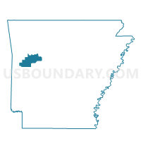
Short Mountain Ward 4, Logan County, Arkansas
About
Outline

Summary
| Unique Area Identifier | 527163 |
| Name | Short Mountain Ward 4 |
| County | Logan County |
| State | Arkansas |
| Area (square miles) | 72.24 |
| Land Area (square miles) | 69.12 |
| Water Area (square miles) | 3.12 |
| % of Land Area | 95.68 |
| % of Water Area | 4.32 |
| Latitude of the Internal Point | 35.32232810 |
| Longtitude of the Internal Point | -93.74750740 |
Maps


Graphs
Select a template below for downloading or customizing gragh for Short Mountain Ward 4, Logan County, Arkansas


Neighbors
Neighoring Voting District (by Name) Neighboring Voting District on the Map
- Voting District 6-A, Franklin County, AR
- Voting District 6-E, Franklin County, AR
- Voting District 7-C, Franklin County, AR
- Clark Rural Voting District, Logan County, AR
- Driggs Voting District, Logan County, AR
- Grant Voting District, Johnson County, AR
- J P Dist 5-B, Franklin County, AR
- Johnson Voting District, Logan County, AR
- Mountain Voting District, Logan County, AR
- Ratcliff Rural Voting District, Logan County, AR
- River Rural Voting District, Logan County, AR
- Short Mountain Ward 1, Logan County, AR
- Short Mountain Ward 2, Logan County, AR
- Short Mountain Ward 3, Logan County, AR
- Ward Voting District, Johnson County, AR
Top 10 Neighboring County Subdivision (by Population) Neighboring County Subdivision on the Map
- Short Mountain township, Logan County, AR (5,011)
- Hogan township, Franklin County, AR (1,514)
- Grant township, Johnson County, AR (1,377)
- Clark township, Logan County, AR (1,261)
- Middle township, Franklin County, AR (1,144)
- Six Mile township, Logan County, AR (1,042)
- Ward township, Johnson County, AR (978)
- Wittich township, Franklin County, AR (898)
- River township, Logan County, AR (650)
- Driggs township, Logan County, AR (517)
Top 10 Neighboring Place (by Population) Neighboring Place on the Map
Top 10 Neighboring Unified School District (by Population) Neighboring Unified School District on the Map
- Ozark School District, AR (10,972)
- Paris School District, AR (7,279)
- Westside School District, AR (3,987)
- County Line School District, AR (3,436)
- Magazine Schools, AR (2,682)
- Scranton School District, AR (2,361)
Top 10 Neighboring State Legislative District Lower Chamber (by Population) Neighboring State Legislative District Lower Chamber on the Map
- State House District 69, AR (31,441)
- State House District 67, AR (30,060)
- State House District 84, AR (25,531)
Top 10 Neighboring State Legislative District Upper Chamber (by Population) Neighboring State Legislative District Upper Chamber on the Map
- State Senate District 6, AR (89,072)
- State Senate District 3, AR (87,143)
- State Senate District 2, AR (83,273)
- State Senate District 4, AR (83,167)
Top 10 Neighboring 111th Congressional District (by Population) Neighboring 111th Congressional District on the Map
Top 10 Neighboring Census Tract (by Population) Neighboring Census Tract on the Map
- Census Tract 9502, Franklin County, AR (7,306)
- Census Tract 9503, Franklin County, AR (6,987)
- Census Tract 9518, Johnson County, AR (4,669)
- Census Tract 9501, Logan County, AR (4,084)
- Census Tract 9503, Logan County, AR (3,946)
- Census Tract 9502, Logan County, AR (3,867)
Top 10 Neighboring 5-Digit ZIP Code Tabulation Area (by Population) Neighboring 5-Digit ZIP Code Tabulation Area on the Map
- 72949, AR (10,177)
- 72855, AR (6,314)
- 72943, AR (2,646)
- 72840, AR (2,149)
- 72821, AR (2,048)
- 72863, AR (1,582)
- 72951, AR (988)
- 72832, AR (923)